παραθέτω μια λίστα με τα πιο ενδιαφέροντα plugins του sdrsharp
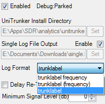
Unitrunker Trunking Plugin
Allows the trunking control software Unitrunker to control the frequencies in SDRSharp. This allows digital and analogue trunking systems to be followed.
επιτρέπει στο προγραμμα για δορυφόρους Orbitron να ελέγχει τη συχνότητα απο το sdrsharp και να ακολουθεί το δορυφόρο καθώς περνάει απο το σημειο που είμαστε εμείς.
μπορούμε να κάνουμε λήψη φωτογραφιών απο δορυφόρο με λιγώτερα απο 30 €
τι ειναι ολα αυτα ?
περίπου στα 800 km πανω απ το κεφάλι μας οι δορυφόροι καιρου κάνουν βόλτες κάποια στιγμή περνάνε και πανω απο την Ελλαδα. μπορουμε να πιασουμε το σημα του δορυφορου χρησιμοποιωντας ενα RTLSDR στικ.μπορουμε να δουμε εικόνες σαν την διπλανή. Σημαντικο ειναι μια καλη κεραια για δορυφόρους
τι χρειαζόμαστε μια κεραια (χρησιμοποίσα μια turnstile) για να κανουμε λήψη τον δορυφόρο , ενα πρόγραμμα (SDRSharp, free), και το software για να μετατρέψουμε το σημα σε εικόνα(WXtoImg, free). Πιστευω οτι ηδη χρησιμοποιειται ενα RTL-SDR stick μαζι με το καταλληλο προγραμμα SDR#. Το πρόγραμμα για τις εικονες απ το δορυφόρο ειναι το WXtoImg και το κατεβάζουμε απο εδω: http://www.wxtoimg.com/downloads/wxinst21011.exe η εγκατάσταση ειναι ευκολη αρκει να ακουλουθήσετε τις οδηγίες
ρυθμίσεις SDRSharp
για το SDR# θα πρεπει να κάνετε τις παρακάτω ρυθμίσεις:
Mode: WFM. Bandwidth: γραφουμε 40000 εδω, 50000 το ανώτερο. Squelch: Off Audio Slider: περίπου στο 70 Input: Cable Output (εχουμε ηδη εγκαταστησει το virtual cable) Output: Cable Input Frequency: You can enter it directly or use the buttons on the top of the screen. Only three frequencies are used - you get them from the imaging software. Satellites are only visible for your radio from a given time, so run SDRSharp 5-10 minutes before the satellite appears. Always double check WFM, 40000, and the Audio settings. Sample Rate: διαλεγουμε το 1,024 MSPS ειναι η καλυτερη επιλογή.
Gain settings
περιπου στο 40. προσπαθουμε να βελτιωσουμε το σημα απ το θορυβο
ρυθμίσεις WXtoIMG
τελευταίες πληροφορίες για τους δορυφόρους: πατάμε File, μετα παμε στο Update Keplers. This gives you the times of satellites. With WiFi it was automatic for me, if not working, go to Options - Internet Options. Information what the software is doing: Bottom left of screen (above blue Microsoft circle) shows you what's happening.
Satellite Pass List, σημαντικό ειναι η ωρα και η συχνότητα του δορυφόρου. Το πρόγραμμα διαβάζει τις ωρα απο το Time Zone και Date απ το Windows Settings. Selecting a good satellite pass: the MEL in Satellite Pass list shows the maximum height of the satellite for your location. Zero is the horizon, 90 is directly above you - higher the number, more signal, better image. Ρυθμιση θεσης: κατω απο το Options - Ground Station Location βαζουμε τη γεωγραφικη θεση μας. Latitude: North is plus, South is Minus. Longitude: East is Plus, West is Minus. ρυθμισεις ηχου: παταμε Options - Recording Options Select Cable Output, so the imaging software can hear what the radio software is saying. Είμαστε ετοιμοι να ξεκινήσουμε.
έλεγχος για πριν το περασμα του δορυφόρου
Do the startup checks 15 minutes before each satellite. During the satellite pass no Facebook, no movies, or you will get horizontal bands in the picture. συνδέστε το stick στον υπολογιστη. τρεχουμε το SDRSharp χωρις την κεραια συνδεδεμενη, test local radio stations - if you can hear them, you need to block the signals by adding more layers of metal around the stick. συνδεστε την κεραια, check again local radio stations. You should see peaks, indicating that the antenna is properly connected. ξεκινηστε το WXtoImg, ελεγχουμε το επομενο περασμα δορυφορου κ τη συχνοτητα. Tune to the given freqency in SDRsharp. Mode WFM, Bandwidth 40000, No Squelch, Audio to almost maximum, Cable output In and Out selected. Press play in SDRSharp. Switch to WXtoImg, File (top left), Record (seventh from top), bottom of the screen press Manual test. Check signal level. Bottom right of the screen, small meter with number in the middle should be green colour, number should be between 50-60. If yellow, audio is not loud enough - Increase in SDRSharp. If red, audio is too loud - Decrease in SDRSharp. ολα καλα ? Go to File, then press Stop - second from the bottom. Check complete, peace of mind that software is working properly.
λαμβάνωντας μια εικόνα
το SDRSharp τρεχει, ελεγχουμε το WFM, 40000, ενταση ηχου και ρυθμισεις ηχου στο CABLE settings. ξεκιναμε το WXtoImg, παμε στο File, μετα record. δευτερη επιλογη ειναι το Record and Auto Process, τσεκαρουμε το Create images. παταμε Auto record. το WXtoImg περιμενει τον δορυφορο,στο κατω μερος αριστερα θα δουμε το το ονομα τη συχνοτητα και την ωρα του δορυφορου. As soon as the satellite appears on the horizon the bottom of the screen changes, program starts recording and you'll start to see something. το πρωτο που θα δουμε ειναι μαυρες και ασπρες γραμμες σε λιγο θα αρχισει να σχηματιζεται η εικονα . περιμενουμε μεχρι να τελειωσει, η εικονα που θα εχουμε θα ειναι ασπρομαυρη για να τη δουμε εγχρωμη παμε στο Enhancements - MCIR Map Colour IR.
προβλήματα
μαυρη εικόνα - το σημα απο το SDR# δεν ειναι δυνατό. Squelch ειναι τικαρισμένο, οι ρυθμίσεις του CABLE δεν ειναι οι σωστές Ασπρες και μαυρες κουκίδες - κατι συμβαινει με την κεραια. - η κεραία πρέπει να τοποθετηθεί πιο ψηλά, η να τη μετακινήσουμε σε αλλο σημείο να βλέπει τον ορίζοντα. - αν δεν μπορειτε να δειτε εικονα τοτε 1) η κεραια δεν ειναι ενταξει 2) το WFM δεν ειναι επιλεγμενο3) λαθος συχνοτητα. Small bands or rows in the image
- Antenna hears an other transmitter. Move to an electrically quiet place like a forest park, nature reserve or a field. - Your computer generates noise. Use ferrite beads on the USB cable for the stick or coil the cable in a small circle. η εικονα ειναι πολυ μαυρη η πολυ ασπρη (μαλλον πολυ μαυρη) το gain στο SDRSharp ειναι πολυ δυνατα - χαμηλωστε σταδιακα. The small bands at the edge of the screen is a good place to start, ideally you should see different shades of gray. Image is shifted, lines on the sides not vertical In WXtoImg, go to Options (fourth from left), then press Resync (sixth from top). One or two lines out of sync might remain, you can't help that.
Tips and tricks
- Print off the satellite pass list in PDF format and keep it on your desktop. Install PDF printer software (doPDF recomended, download from here, opens in new window),then you won't need to open WXtoImg to check the times of the next pass. Saves time for a quick check. - Check, then double-check settings in both SDRSharp and WXtoImg, because the two programs must work together for best results. - WFM μας δινει την καλυτερη εικονα. - 40000 as it is a nice big number and only requires two buttons. I've seen no difference with 45000. It can not be less than 37000. Noise-free images are a result of: μια καλη κεραια - φιταξτε μια QFH Clear view of the sky - no trees, buildings between you and the antenna No electrical noise - cover the stick in metal, move out of the city. Satellite high on your horizon - choose a satellite from the Satellite Pass list with a MEL as close to 90 as possible. MEL Numbers less than 30 are usually full of banding and noise. Image on top of the page is from a pass with an MEL of 87. Pre-amplifier - also called a low-noise amplifier, it increases the signal more than a hundred times. The gain in SDRSharp is only needs to go up to 28 db, so less internal noise is generated in the stick. A good one costs 25 euros, currently testing one.


 το πρωτο που θα δουμε ειναι μαυρες και ασπρες γραμμες σε λιγο θα αρχισει να σχηματιζεται η εικονα .

